Program for automatic extraction and longitudinal visualization of topographic cross section
Easy viewing of curved topography! Useful program for management of river, road, waterway, coastline, etc.!
Overview
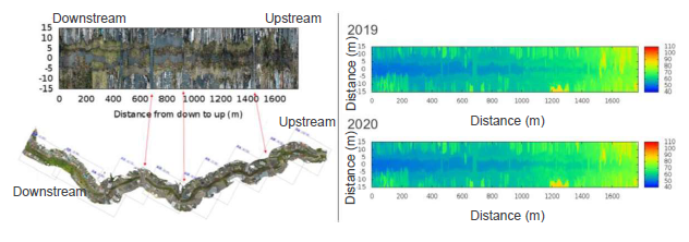
Point cloud data obtained from UAV photogrammetry is processed to
create orthomosaic image, bird's eye view and 3D model, in order to
understand the topography. However, in curvilinear topography such as
river, road, waterway and coastline, it is difficult to grasp the whole picture
of the curvilinear topography and its surrounding areas because these
models are displayed in curvilinear form as they are.
This technology provides a method and a program that can easily grasp
curved topography visually. It has concretely the following features.
◆Automatic extraction of cross-sections from 3D point cloud
◆Easy viewing of the entire image by linear arrangement of curved
topography
◆Able to compare topography changes over multiple time period
◆Obtain elevation of cross-sectional and longitudinal sections of
the target topography
◆Display seasonal changes of the surrounding environment
(vegetation, etc.)

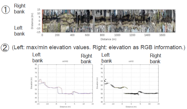
① longitudinal view and ② cross-sectional figure at a given point

Product Application
・Topography management and survey
・Map creation
Related Works
HASHIMOTO Masakazu, SATO Shosuke, ICHIKAWA Ken, NARADATE Susumu, SATO Keiji, AMAYA Kaori, NASUNO Arata: “Estimation of flood overtopping points using 3D point cloud data generated by UAV approach”, 38th Japan Society For Natural Disaster Science annual conference abstract, p89-90, 2019
IP Data
IP No. : JP6877706
Inventor : Tohoku University: HASHIMOTO Masakazu, SATO Shosuke
Fukken Gijyutsu Consultants Co.,Ltd.: ICHIKAWA Ken, NASUNO Arata, AMAYA Kaori
keyword : Software
